Southern Marin Christmas Bird Count Historical Data by Species and Area Maps

This page is a wonderful resource if you’re interested in the data we’ve obtained from our Count over the years, or would like to download a map of the area where you will be counting. It includes data sheets for the entire Count, and for each individual area. Each data sheet provides the complete numbers, by species, of all birds that were counted on each year’s CBC, from 1978 through 2009. Participants can use these sheets to determine which species they might expect to see in a particular area. Also, there are maps for the each area, and one with an overview of the complete Count circle. All the files are in PDF format, and you can save them on your computer for further analysis.
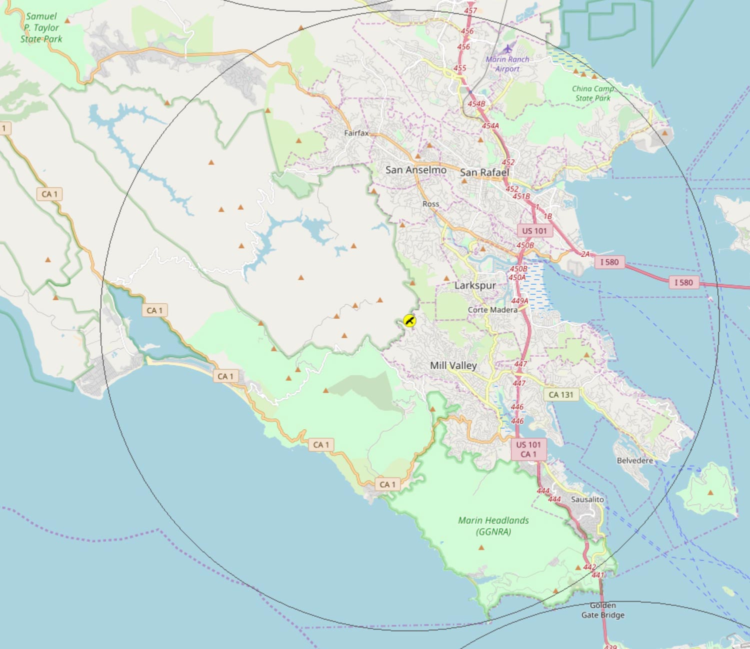
Click image below for larger version

Area Maps

Count Circle map with areas.pdf Count Circle map.pdf
ALPINE LAKE list.pdf Alpine Lake map part 1.pdf Alpine Lake map part 2.pdf  
AUDUBON CANYON list.pdf AUDUBON CANYON map.pdf    
Bay map 1.pdf Bay map 2.pdf Bay map 3 – portion.pdf  
Bolinas Lagoon list.pdf BOLINAS map.pdf BOLINAS map 2.pdf  
Bon Tempe list.pdf Bon Tempe map 1.pdf Bon Tempe map 2.pdf  
Corte Madera Marsh List.pdf CORTE MADERA MARSH map.pdf    
Fairfax list.pdf Fairfax map.pdf    
Ft Cronkhite List.pdf Ft Cronkhite Map 1.pdf Ft Cronkhite Map 2.pdf Ft Cronkhite Map 3.pdf
Larkspur – Corte Madera list.pdf Larkspur – Corte Madera map.pdf    
Mill Valley list.pdf Mill Valley map.pdf    
Mill Valley Marsh list.pdf Mill Valley Marsh map.pdf    
Muir Beach List.pdf Muir Beach Map 1.pdf Muir Beach Map 2.pdf Muir Beach Map 3.pdf
Muir Woods list.pdf Muir Woods map 1.pdf Muir Woods map 2.pdf  
Offshore – full count circle map.pdf Offshore list.pdf Offshore map alt partial.pdf  
Offshore map part 1.pdf Offshore map part 2.pdf Offshore map part 3.pdf  
PHOENIX LAKE list.pdf PHOENIX LAKE map.pdf    
Rock Springs – Mt Tam list.pdf Rock Springs – Mt Tam map Part 1.pdf Rock Springs – Mt Tam map Part 2.pdf  
San Rafael list.pdf San Rafael map.pdf    
Sausalito list.pdf Sausalito map.pdf    
Stinson Beach list.pdf STINSON BEACH map.pdf    
STRAWBERRY list.pdf STRAWBERRY map.pdf    
Tennessee Valley List.pdf Tennessee Valley Map.pdf    
Terra Linda list.pdf Terra Linda map.pdf    
Tiburon list.pdf Tiburon map.pdf    


Data from Past Counts

CBC-S Marin – Larkspur 2010-2018

CBC-S Marin – Fairfax 2010-2018

CBC-S Marin – Corte Madera Marsh 2010-2018

CBC-S Marin – Bon Tempe Lake 2010-2018

CBC-S Marin – Bay-2010-2018

CBC-S Marin – Audubon CanyonRanch 2010-2018

CBC-S Marin – Alpine Lake 2010-2018

2013 Southern Marin CBC Results.pdf

2009 S Marin CBC – All Areas.pdf

S Marin CBC 2008 Areas.pdf

S Marin CBC 1975-2009.pdf

S Marin CBC 1978-2009 – Alpine Lake.pdf

S Marin CBC 1978-2009 – Audubon Canyon Ranch.pdf

S Marin CBC 1978-2009 – Bolinas Lagoon.pdf

S Marin CBC 1978-2009 – Bon Tempe.pdf

S Marin CBC 1978-2009 – Corte Madera Marsh.pdf

S Marin CBC 1978-2009 – Feeder Watchers.pdf

S Marin CBC 1978-2009 – Fort Cronkhite.pdf

S Marin CBC 1978-2009 – Larkspur.pdf

S Marin CBC 1978-2009 – Mill Valley Marsh.pdf

S Marin CBC 1978-2009 – Muir Beach.pdf

S Marin CBC 1978-2009 – Muir Woods.pdf

S Marin CBC 1978-2009 – Off-Shore.pdf

S Marin CBC 1978-2009 – Phoenix Lake.pdf

S Marin CBC 1978-2009 – Rock Springs.pdf

S Marin CBC 1978-2009 – San Rafael.pdf

S Marin CBC 1978-2009 – Sausalito.pdf

S Marin CBC 1978-2009 – Stinson Beach.pdf

S Marin CBC 1978-2009 – Strawberry.pdf

S Marin CBC 1978-2009 – Tennessee Valley.pdf

S Marin CBC 1978-2009 – Terra Linda.pdf

S Marin CBC 1978-2009 – Tiburon.pdf

S Marin CBC 1980-2009 – Mill Valley.pdf

S Marin CBC 1982-2009 – Fairfax.pdf

S Marin CBC 1988-2009 – Richardson Bay.pdf

Field Trips

Apr 01

Nicasio / Tomales Bay – Birding in Marin – Season 8, Trip 4

APRIL 1 @ 8:30 AM - 3:00 PM

Saturday, April 1st – 8:30 AM to mid-afternoon
With Jim White and Bob Battagin
Register HERE for this field trip 
Registration for this trip is required. Registration opens Wednesday, March 22 at 8 AM. 

The rolling hills of central Marin are covered with pastures, horse ranches, forested ridges, homes, reservoirs and occupied by many interesting birds. We will look for them in and around Nicasio and along the nearby stream before heading three miles north to see what is on and around Nicasio Reservoir. This is Bob’s birding “patch” and he has found both Bald and Golden Eagles recently with a nice array of other birds in this vicinity.

We expect to travel the few miles to Point Reyes Station for a lunch break or picnic. In the after- noon we will explore the south end Tomales Bay. Then, as time allows, we can explore the eastern edge of Tomales Bay along Highway 1, which supports a winter population of thousands of ducks, geese and shorebirds. We might travel 10 miles north to see if an Eagle’s nest is having success. Heavy Rain cancels.

DIRECTIONS: From Hwy 101 in north San Rafael take Lucas Valley Rd west 10.3 miles then right turn onto Nicasio Valley Rd for 0.5 miles and park near the baseball field, the center of town. For GPS use 1 Old Rancheria Rd Nicasio, the address for the Rancho Nicasio Restaurant. Meet at ball field in Nicasio.

Apr 06

The Ponds at Las Gallinas Sanitary District (LGVSD) – San Rafael

APRIL 6 @ 8:30 AM - 11:30 AM

Thursday, April 6, 2023
8:30 to 11:30 AM
Birding with Sande and Bob Chilvers 

All participants are welcome to join this trip. No registration required. 

Beginning birders are especially welcome on the first Thursday of each month for a leisurely walk around the Las Gallinas ponds. Join our friendly leaders as we search for waterfowl, waders, songbirds, raptors, and shorebirds. Bird enthusiasts of all levels help each other to find and identify the birds, and there are usually several experienced birders to assist. You don’t even have to arrive on time because we spend the first 30 – 60 minutes studying the birds around the first pond and the group is easy to find. Heavy rain cancels. 

DIRECTIONS: From Hwy 101, exit at Smith Ranch Rd. Drive east on Smith Ranch Rd toward McInnis Park. Turn left immediately after crossing the railroad tracks and drive about 0.5 mile through the LGVSD gates and into the parking lot at the end of the road. Meet the group by the bridge just past the parking lot. There is an outhouse in the parking area for public use. 

Apr 12

Rodeo Lagoon – Marin Headlands

APRIL 12 @ 7:30 AM - 12:00 PM

Wednesday, April 12, 2023 – 7:30 AM to noon
Birding with William Legge & David Wiechers
Register HERE for this field trip

Registration is required for this trip. Registration opens April 2 at 8:00 AM.

With spring migration underway will be looking out for migrant wildfowl, shorebirds, grebes, loons and passerines. As usual, the weather will dictate our focus with onshore northwest winds ideal for spring sea watches, while offshore easterly winds promise a good selection of passerine migrants. Join us for a Sea Watch at 7:30 AM or arrive later at 8:30 AM for a circuit of the lagoon.

DIRECTIONS: Head south on Hwy 101 and take the last Sausalito exit just before the Golden Gate Bridge. At the exit stop sign, turn right and go under the freeway, then follow the road down to the left. Within 300 feet turn left at the sign to the Marin Headlands; this is the only available left turn before you begin the descent into Sausalito. You should see the tunnel with the five-minute signal light. Proceed through the tunnel on Bunker Road to the Rodeo Lagoon Parking Lot at the end and meet by the bridge over the channel to the beach. 

May 04

The Ponds at Las Gallinas Sanitary District (LGVSD) – San Rafael

MAY 4 @ 8:30 AM - 11:30 AM

Thursday, May 4, 2023
8:30 to 11:30 AM
Birding with Sande and Bob Chilvers 

All participants are welcome to join this trip. No registration required. 

Beginning birders are especially welcome on the first Thursday of each month for a leisurely walk around the Las Gallinas ponds. Join our friendly leaders as we search for waterfowl, waders, songbirds, raptors, and shorebirds. Bird enthusiasts of all levels help each other to find and identify the birds, and there are usually several experienced birders to assist. You don’t even have to arrive on time because we spend the first 30 – 60 minutes studying the birds around the first pond and the group is easy to find. Heavy rain cancels. 

DIRECTIONS: From Hwy 101, exit at Smith Ranch Rd. Drive east on Smith Ranch Rd toward McInnis Park. Turn left immediately after crossing the railroad tracks and drive about 0.5 mile through the LGVSD gates and into the parking lot at the end of the road. Meet the group by the bridge just past the parking lot. There is an outhouse in the parking area for public use. 

May 06

Mount Burdell / Stafford Lake or Rush Creek – Birding in Marin, Season 8, trip 5

MAY 6 @ 8:30 AM - 3:00 PM

Saturday, May 6, 2023
8:30 AM to mid afternoon
Birding with Jim White and Bob Battagin
Register HERE for this field trip

Registration for this trip is required. Registration opens April 26 at 8:00 AM.

Join Jim and Bob for a field trip to the gentle slopes of Mount Burdell where we’ll listen to and observe the impressive variety of songbirds that make this area their springtime home. Species we might see include Lark Sparrow, Ash-throated Flycatcher, Bullock’s Oriole, Lazuli Bunting and Grasshopper Sparrow, among may other possibilities. In the afternoon, we plan to continue birding at Stafford Lake or Rush Creek.

This will be a moderate hike with many opportunities to look at birds and spring wildflowers. Wear comfortable walking shoes and layered clothing. Bring water and snacks. We will meet at the end of San Andreas Drive in Novato.

DIRECTIONS: Take Hwy 101 to Novato, exit at the San Marin Dr/Atherton Ave exit. At the end of the exit ramp, turn left (west) on San Marin Dr. Go approximately two miles and turn right on San Andreas Dr. Drive nearly to the end of the road and park on the street. No restrooms available.